The geography of ancient Rome is less evident nowadays
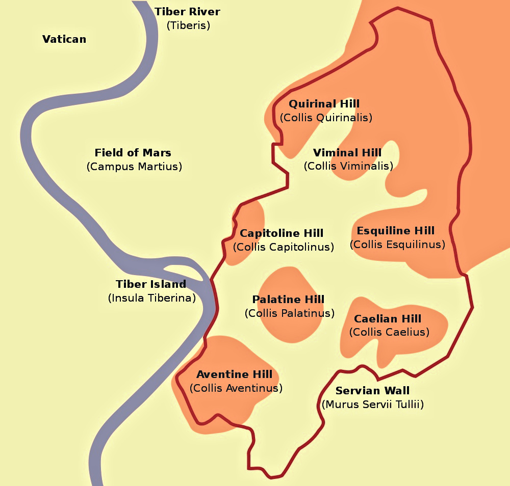
The geography of ancient Rome was in many ways the contributing factor behind its future success, so much so that even Roman writers such as Cicero, acknowledged how fortunate the choice had been. Its geography is characterized by fairly steeped hills on the left bank of the Tiber River, at the tip where the river poured around a small island as well as branching out into peaty areas between the hills themselves.
The geography of ancient Rome is less evident nowadays, greatly owed to thousands of years of continuous transformation and building. The hills which were of great strategic importance, because of their position and height, have been cut away and constructed over; however, they can still be visible to an expert eye.
The swampy nature of the geography of ancient Rome is also not apparent except perhaps to those people who own the damp cellars of the city. The renowned “Great Drain”, the Cloaca Maxima, and its extensive network of drainage waterways did a great deal to consign the rivers and streams underground. However, this does not mean that the city’s water courses were being disregarded; different sections of the Cloaca Maxima were and are, spacious enough to drive a horse and cart down it for inspection rounds. In fact, the drain itself to this day, still functions.
Seven Hills of Rome the famous Rome’s geographical thing
Another essential facet of the geography of ancient Rome is the Tiber River, which gave the city an on hand access to the sea and trading routes. A marsh was later transformed into a port and a cattle market called the Forum Boarium. The importance of the river was immense that it deserved its own embodied self in the statue with plenty of horns and an oar protecting Romulus and Remus, which justifies an element of truth in every myth: The Tiber River gave a tremendously important element in the history of the city’s success.
A lot of the city’s engineering buildings and structures, were made using readily available materials, as the geography of ancient Rome sits on an area which was once subject to volcanic activity, giving it a plentiful supply of a selection of stones and rocks such as hard Basalt, which were used for paving roads, and the Travertine marble which was used to line the Colosseum. Peperino, Clay, Tufa, and many more, were a great mixture if building techniques.
A point note worthy, in Rome’s geography is the famous “Seven Hills of Rome”, which has changed through the ages. The city in fact overlaps with one or two more than seven, and that’s even before counting the other couple over the river, the Gianniculum and Vaticanus hills. Rome’s situation in the very heart of Italy has all the advantages making it of all places in the world, a city destined to grow great.